This page describes the GIS workflow to extract the distances along the Missouri River sailing line for each of the USACE surveyed cross sections. These distances along the sailing line will be incorporated into the cross section viewer and used instead of river mile distances for all longitudinal calculations.
Overview
The ArcGIS Location Features Along Routes geoprocessing tool was used to identify the distance along the sailing line where each cross section intersects the sailing line. The inputs provided by USACE were:
- Cross sections ShapeFile containing a separate polyline feature for each surveyed cross section on the Missouri River. The attribute Field xsection_id contains the database IDs of each cross section.
- River network sailing line ShapeFile containing a separate polyline feature for the major channels in the Missouri river drainage.
The tools used were:
- ArcGIS 10.1 Service Pack 1.
- Microsoft Excel.
Workflow
1) The river network ShapeFile was added to ArcMap. The feature representing the mainstem of the Missouri river was selected and then the “Export Data” feature of ArcMap used to export just the selected feature into its own ShapeFile. This one feature represented the entire Missouri river while the analysis only required the lower XXX miles. So the output ShapeFile was edited and the mainstem split at approximately river mile XXX. The upstream section was deleted, leaving a line representing just the lower section of the Missouri River.
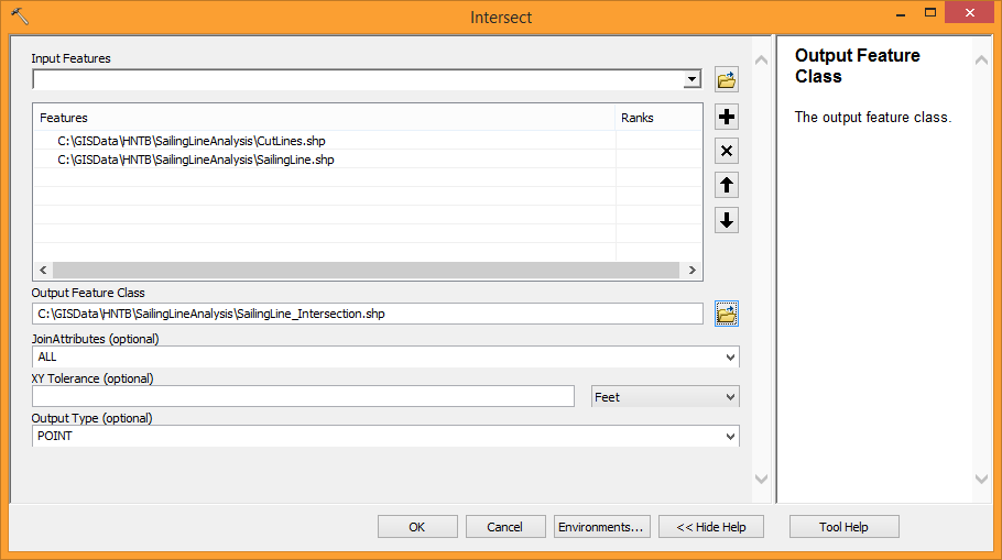
2) The lower Missouri River ShapeFile was intersected with the Cross Sections ShapeFile to produce a point ShapeFile containing the locations where the cross sections meet the sailing line.
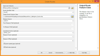
3) The Create Routes geoprocessing tool was used to prepare the lower Missouri River ShapeFile for the analysis. This tool indexes the geometry in the ShapeFile and makes it eligible for further linear referencing tasks. The inputs to the tool were as follows:
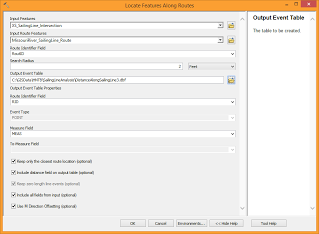
4) The Locate Features Along Routes geoprocessing tool was used to extract the distances of the cross section intersect points from the sailing line. Note that the inputs to this tool included the sailing line route (not the original sailing line ShapeFile, but the output of step 3). Also note that a search tolerance of 2ft was used to ensure that all the intersect points achieved a match with the sailing line. Using a value of zero meant that some points were omitted from the output because they didn’t reside on the sailing line precisely (despite being produced by an intersect analysis earlier in the workflow.)
5) The output of step 3 was a DBF table that can be opened in Microsoft Excel. The table contains both the cross section IDs (via the intersect points) and the distance along the sailing line. Upon review, the distances were discovered to originate from the upstream end of the lower Missouri River polyline and so each value was subtracted from the total distance of the line (obtained from the attribute table to be 2641302.39 ft) to obtain the sailing line distance from the downstream end.
6) As a validation check, 10 cross sections within the first and last mile of the lower Missouri River where selected and their distances along the sailing checked by hand using the ArcGIS measure tool. All values were verified to be correct. (Note that each vertex of the sailing line must be clicked on for the measure tool to provide identical results. The results will only match approximately if the measure tool is used from cross section point to cross section point.)
The final results of this analysis are attached at the bottom of this page.