You can export cross section elevation data in several plain-text formats. This tool operates on a single cross section selection and for one or more surveys.
Click on export cross sections from the tools menu in the cross section viewer. First ensure that a selection exists containing just the cross sections in question. Remember that you can copy, merge and edit existing selections to achieve the desired set of cross sections. Then switch to the Surveys tab and select one or more surveys that you want to include in the export. Hold down the CTRL key while clicking to select multiple surveys.
When multiple surveys are exported, their data appears sequentially in the output text file.
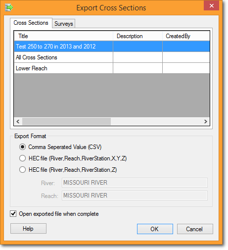
Cross Sections - Single click on the one selection in the list that contains the cross sections that you want to export. The selection in question will be highlighted in blue.
Export Format - Choose between one of three plain-text export formats:
Comma Separated Value (CSV) Format
The following cross section fields are written to the file, separated by commas:
SurveyName- The name of the survey to which the survey data belong.CrossSectionID- The internal numerical identifier of the cross section. If your database identifies cross sections by river mile or station then this ID will not be user defined, and instead it merely represents an arbitrary, internal ID used by the software to identify each cross section.RiverMile- the longitudinal river mile of the cross section along the channel.SailingLineDistance- the centerline distance of the cross section along the channel. This will be identical to the river mile if separate centerline distances have not been provided*.Easting- The UTM easting coordinate of each survey point for the selected survey.Northing- The UTM northing coordinate of each survey point for the selected survey.Elevation- The elevation of each survey point for the selected survey.Date- the date that the survey point was collected*.Station- the distance of the survey point from the left bank.Offset- the Euclidean distance of the point that was actually surveyed from the position on the monumented cross section that it represents*.Survey Point Code- survey point metadata that was included with the survey during data import.
*Certain fields are not populated in all cross section databases and will appear in export files as null values. That is, all cross sections are exported for one survey, then a new line is inserted, and then the cross section data for the next survey is written.
Sample CSV export file
SurveyName,CrossSectionID,RiverMile,SailingLineDistance,Easting,Northing,Elevation,Date,Station,Offset
2013,6544,250.02,250.02,1610125.29,14301696.79,618.2,08242013,1102.57,-2.12
2013,6544,250.02,250.02,1610123.97,14301701.75,617.42,08242013,1097.44,-1.81
2013,6544,250.02,250.02,1610123.33,14301705.42,616.53,08242013,1093.76,-1.27
2013,6544,250.02,250.02,1610122.05,14301710.17,615.65,08242013,1088.85,-0.99
2013,6544,250.02,250.02,1610119.79,14301714.91,614.86,08242013,1083.64,-1.65
...
HEC Formats
The cross section viewer exports survey data in two Hydrologic Engineering Center-Hydrogolic River Analysis System (HEC-RAS) compatible formats. Both formats include a river and reach name that is editable from the cross section viewer export form. These two inputs default to the values provided when the cross section database was created.
The main difference between the two HEC-RAS formats is the inclusion or omission of the UTM easting and northing of every survey point.
HEC-RAS River, Reach, Station, X, Y, Z Format
River,Reach,RS,X,Y,Z
MISSOURI RIVER,MISSOURI RIVER,250.24,1609186.5,14301207.1,618.8
MISSOURI RIVER,MISSOURI RIVER,250.24,1609183.39999999,14301213.6999999,615.5
MISSOURI RIVER,MISSOURI RIVER,250.24,1609181.89999999,14301216.1999999,613.9
MISSOURI RIVER,MISSOURI RIVER,250.24,1609178.5,14301220.3,611.9
MISSOURI RIVER,MISSOURI RIVER,250.24,1609174.39999999,14301224,610.3
...
HEC-RAS River, Reach, Station, Z Format
River,Reach,RS,Z
MISSOURI RIVER,MISSOURI RIVER,250.24,618.8
MISSOURI RIVER,MISSOURI RIVER,250.24,615.5
MISSOURI RIVER,MISSOURI RIVER,250.24,613.9
MISSOURI RIVER,MISSOURI RIVER,250.24,611.9
MISSOURI RIVER,MISSOURI RIVER,250.24,610.3
MISSOURI RIVER,MISSOURI RIVER,250.24,609.1
...