The test generator is used to create a new cross section database with a series of simple, generic cross section data. These simplified cross sections are useful for understanding and validating the calculations underlying other tools within the cross section viewer software.
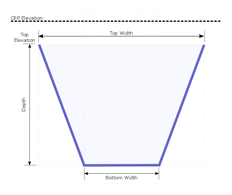
The cross sections generated by this tool are simple trapezoids, the dimensions of which are customizable by the user. All cross sections possess a wide horizontal top and a narrow horizontal bottom, with sloping sides. These cross sections are defined by four survey points. One high point on the left end, two lower points at the same bottom elevation and then a final point on the right end of the cross section at the same elevation as the first point.
Cross sections at intervals over a user-defined reach. The size of the cross sections at the top and bottom of the reach are specified by the user and then the software interpolates additional cross sections at a user-defined interval along the reach.
The tool is capable of generating multiple surveys, each with cross sections of different dimensions. As a final step, the generator also creates a selection in the output database that contains all cross sections in the database. Test cross section databases are currently only generated using feet and the NAVD88 vertical datum.
Steps To Generate Test Database
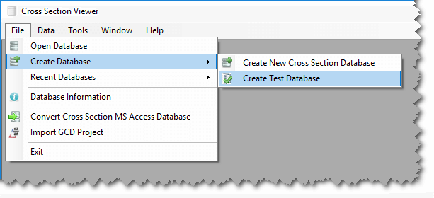
Launch the test data generator from the Tools menu in the Cross Section Viewer software.
In the test data generator form that appears enter the following:
River Dimensions
Downstream - The river mile of the most downstream cross section that will be generated in the test database. The downstream river mile must be less than the upstream river mile and valid values are from zero to 1,000.
Upstream - The river mile of the most upstream cross section that will be generated in the test database. The upstream river mile must be greater than the upstream river mile and valid values are from zero to 1,000.
CRP Elevation - This is the elevation (in feet) of a reference plane that will be generated in the test database. Nominally called a “construction reference plane” this can be any horizontal plane from which you want to calculate cross section profile areas. Typically, this plane is above the uppermost elevation of all cross sections, but that is not mandatory. The CRP elevation does not affect cross section profiles. Valid values are from 1 to 10,000ft.
XS Spacing - This is the longitudinal distance between cross sections. The test generator uses this spacing as the interval for laying out cross sections between the upstream and downstream river miles. The process of generating the cross sections starts at the downstream river mile and moves upstream. So if the distance between the downstream and upstream river miles is not evenly divisible by the spacing, the final cross section will not be precisely on the upstream river mile. Valid spacing values are from 0.1 to 100 miles.
RCL Stations
The rectified channel stations represent a pair of reference stations that are used for certain cross section measurements. The left and right stations are specified in ft from the left bank, and the same stations are used for all cross sections. Like the CRP, the RCL stations are independent of the cross sections and do not affect their size and shape. Valid RCL values are from 0 to 100 and the left station must be less than the right station.
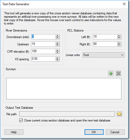
Surveys
The user can specify multiple surveys for the test database. Each survey possesses data at each of the cross section river miles defined by the upstream, downstream and spacing inputs. Surveys control the shape of cross sections. So creating multiple surveys allows the user to vary the shape of cross sections in different ways for different surveys. This can be useful for exploring the calculations in the cross section viewer and how they vary with different cross section shapes. A minimum of one survey is required.
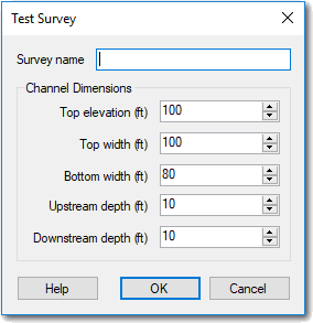
Survey Name - Each survey must have a unique name. It’s a good idea to incorporate the cross section dimensions into the survey name (“e.g. Survey with Top 100, Bottom 80, US Depth 10, DS Depth 20”).
Channel Dimensions
The channel dimensions control the shape of cross sections for individual surveys (see illustration at top of page). The top elevation, top width and bottom width are constant for all cross sections in the survey. The bottom elevation of each cross section is controlled via the depth inputs. Users can define constant cross sections down the channel by specifying the same upstream and downstream depths, or vary cross sections between two depths. The bottom elevation for each cross section is determined by interpolating its depth based on the longitudinal position of the cross section between the upstream and downstream river mile.
Top elevation - The constant, horizontal elevation of the start and end survey points on each cross section. Values are in feet and the valid range is from 0 to 10,000.
Top width - The constant horizontal distance between the start and end survey points on each cross section. The left station is always at station zero, and so this width essentially becomes the station of the right-most survey point. Values are in feet and the valid range is from 0 to 1000 and must be greater than the bottom width.
Bottom width - The width of the horizontal base of the cross section. This base is position equidistant from the left and right ends of the cross section, so that the profile of the cross section is symmetrical about the channel centerline. Values are in feet and the valid range is from 0 to 1,000 and must be less than the top width.
Upstream depth - This is the vertical distance between the first survey point and the lowest points on the cross section, for the most upstream cross section in the survey. Values are in feet and the valid range is from 1 to 1,000 and must be less than the top width.
Downstream depth - This is the vertical distance between the first survey point and the lowest points on the cross section, for the most downstream cross section in the survey. Values are in feet and the valid range is from 1 to 1,000 and must be less than the top width.
Output Test Database
The user must specify the file path for the output test database that is generated. The user has the option to close the current database and open a connection to the new test database that is generated.