Construction reference planes (CRPs) represent artificial surfaces that can be used as an elevation datum. They provide an alternative to sea level against which to reference elevations. CRPs are represented by a series of vertical inflection points at specific river miles along the river.
Several of the analytical tools within the Cross Section Viewer software use CRPs as a uniform upper elevation for constraining cross section area calculations. For example, the first and last elevations of a single cross section may be different and require a uniform reference elevations for calculating a profile area. Moreover these two end point elevation might also be different between surveys. By extending cross sections up to an artificial, unchanging datum above the channel, a consistent upper extent can be established allowing for calculations to only differ by the channel bathymetry.
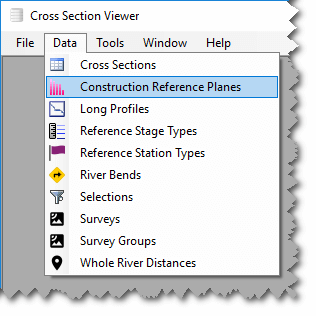
To view Construction Reference Planes (CRP), select Data from the main menu and then Construction Reference Planes.
The Edit menu allows you to add, edit and delete CRPs.
Add a New CRP
- Open the CRP table by clicking
Dataand thenConstruction Reference Planesfrom the main Cross Section Viewer menu. - Click
Addfrom theEditmenu. - Provide a unique
Namefor the CRP (it must be different from existing CRPs in the current database). - Optionally you can provide some remarks to describe the CRP.
- Click OK to save the CRP.
With the new CRP in the database you can proceed to import inflection points into this CRP.
Edit a CRP
- Open the CRP table by clicking
Dataand thenConstruction Reference Planesfrom the main Cross Section Viewer menu. - Select the desired CRP and either:
- Double click the CRP
- Right click and choose
Edit - Choose
Editfrom theEditmenu.
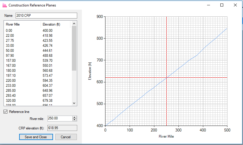
The window that appears shows the inflection points for the selected CRP. You cannot change the inflection points on this screen, but you can edit the name and click Save and Close to commit your changes and this data can be edited in Microsoft Access.
The main feature of this CRP properties view is to show the elevations of all the inflection points by river mile. You can calculate the elevation of any desired river mile value using the river mile data entry box at the bottom of the screen. Click on the box and enter a numeric value then press tab to move off the data entry box. Alternatively you can use the up and down arrows to seek the desired river mile. As the river mile value changes, the elevation will be interpolated and show in the CRP elevation box as well as a red crosshairs on the main plot. This calculation uses simple interpolation between the two closest CRP inflection points to determine the desired elevation. Note that you can’t calculate a CRP elevation beyond the most upstream or downstream CRP inflection points.