Users can create new, empty databases into which they then import their cross section data. To create a new cross section database you must provide the information described below. Note that the selections made at the time of creating the database are permanent and cannot be changed once the database is created.
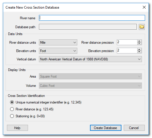
River name - The name of the river that the cross section data pertain to. This can be the name of a reach, chute, channel etc that describes, at high level, the data being stored. The river name is mandatory.
River Distance Units - the units of measurement used to measure the longitudinal separation up and downstream between cross sections.
Elevation units - the units of measurement used for the cross section stations and elevations. Both station and elevation measurements must use the same units.
River Distance Precision - the display precision for river distance measurements. The actual values are stored using 8-byte IEEE floating point number.
Elevation Precision - the display precision for station and elevation measurements. The actual values are stored using 8-byte IEEE floating point number.
Vertical datum - Choose the vertical datum used for the cross section elevations. The software currently allows for NAVD88 and NGVD29. All elevation data in a single cross section database must be on the same vertical datum.
Cross Section Identification - Select one of the options describing how cross section data will be identified in the new database. See below for an explanation.
Cross Section Identification
The cross section viewer maintains a master list of cross sections that represents the position along the river where transects are collected. All survey data is referenced to this master list. The software uses one of three ways to identify cross sections in this master list:
Unique Numerical Identifier - This is a unique ID for each cross section. The minimum allowable number is 1 and the maximum is 263-1. There are no constraints on the system of numbering, but typically numerbering starts downstream with the number 1, increasing in an upstream direction. When using IDs to identify cross sections, you must also specify the corresponding river distance (see next bullet).
River Distance - The river distance (in the units specified above) used to identify cross sections must be unique, positive values (i.e. one cross section at each river distance value). The river distance can be based on an arbitrary reference point (e.g. a confluence or structure) and does not have to refer to the outflow into the ocean or another river.
Stationing - River stations take the form of 0+00 where the first digit refers to hundreds of feet upstream of an arbitrary reference point. The second value is the number of feet upstream of the corresponding hundred foot station. For example a station of 1+2.3456 would refer to a cross section 102.3456 upstream of the reference point. When cross section stations are imported into the database they are converted to river distances in the background to support the calculation of control volumnes and longitudinal analyses.