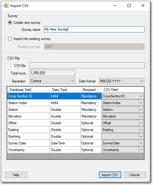
Survey data can be imported into either a new or existing survey. The data must be in a comma separated value (CSV) plain text format that contains a single header row of column names ([] sample below)](#sample-csv-file). Different fields are required depending on method used to identify cross sections in the current database.
The CSV data must contain the station (distance along the cross section) as well as the vertical elevation of each survey point. These values must be in the same units as the datase into which the data are being imported. Moreover the elevation values must also use the same vertical datum as the database. Refer to the [database information(/Online_Help/File_Menu/#database-information) screen if you are unsure.
In the current version ofthe software, the columns in the text file must be separated by commas (not tabs etc). Strings should not be wrapped in quotes.
Note that when a database uses IDs to indentify cross sections, that the CSV file can only include cross sections that are already defined in the database. The CSV importer will fail if the CSV file contains cross section IDs that are not already defined in the current database.
Required Fields
The fields that are required in the CSV file depend on the way in which cross sections are defined in the current database:
| CSV Column | Data Type | Cross Sections Idenfitied By ID | Cross Sections Identified by River Distance | Cross Sections Identified by Stationing |
|---|---|---|---|---|
| Cross Section ID | Int64 | Mandatory | NA | NA |
| River Distance | Double | NA | Mandatory | NA |
| River Station | String | NA | NA | Mandatory |
| Station Index | Int64 | Mandatory | Mandatory | Mandatory |
| Station | Double | Mandatory | Mandatory | Mandatory |
| Elevation | Double | Mandatory | Mandatory | Mandatory |
| Offset | Double | Optional | Optional | Optional |
| Easting | Double | Optional | Optional | Optional |
| Northing | Double | Optional | Optional | Optional |
| Survey Date | DateTime | Optional | Optional | Optional |
| Vertical Uncertainty | Double | Optional | Optional | Optional |
| Survey Point Code | Text | Optional | Optional | Optional |
Cross Section ID
This is the integer identifier that uniquely identifies each cross section. The integers in the CSV must already exist in the database or an error will be reported. This column is not needed if the database identifies cross sections by river distance or stationing.
River Distance
This is the river distance of the cross section for which the survey points apply. Unlike with CrossSectionID, if a cross section at the specified river distance is not already defined in the database then a new cross section is defined using the river distance value from the CSV file.
River Station
This is the text label that defines each cross section. Each label in the CSV file must already be associated with a cross section defined in the database or an error will be reported.
Station Index
This integer defines the sequence of survey points along a cross section. Each survey point must have a unique integer value, but they need not start with 1 for each cross section.
Station
This is the horizontal distance along the cross section for a particular cross section. The units must be the same as the elevation units defined in the cross section database. Refer to the database information screen if you are unsure.
Elevation
The elevation of each survey point. The units and vertical datum must be the same as those defined in the database.
Offset
This optional value can be used to store the Euclidean distance of the surveyed point from the theoretical line that represents the monumented cross section.
Easting
This optional value can be used to store either the geographic (unprojected) longitude or the cartesian (projected) map easting of the survey point.
Northing
This optional value can be used to store either the geographic (unprojected) longitude or the cartesian (projected) map northing of the survey point.
Survey Date
This optional value can be used to store the date on which a cross section was surveyed. Note that the only the survey date of the first record for each cross section is stored. Subsequent survey dates are ignored. In other words, each cross section is assumed to be surveyed in its entirity on a single date. Use the survey date format property to define the way in which dates are represented in the CSV file. All dates MUST confirm with this format or an error will be reported.
Vertical Uncertainty
This optional value can be used to define the vertical uncertainty with each survey point. The main cross section plot can represent this value as error bars when it is present.
Survey Point Code
Include miscellaneous text pertaining to each point using the survey point code column. This can be used for point quality information or other descriptors such as “edge of water” etc. Be sure not to include any commas in the text! Currently this survey point codes do not appear anywhere in the software, but they are included in the cross section export when data are exported from the database.
Sample CSV File
The following is a sample CSV file for three cross sections on the Missour River near Kansas City, US.
CrossSectionID,StationIndex,Station,Elevation,Easting,Northing_Test,Offset,Uncertainty,SurveyDate
1,1,55.83769989013672,399.052001953125,2462905.07,14105797.12,3.2751550674438477,,
1,2,65.9736099243164,397.9419860839844,2462895.43,14105793.6,3.2751550674438477,,
1,3,76.06612396240234,395.86199951171875,2462885.59,14105791.33,3.617654800415039,,
1,4,86.26123809814453,390.0220031738281,2462875.54,14105789.6,3.389902353286743,,
1,5,96.45808410644531,384.6820068359375,2462865.43,14105788.17,2.8559486865997314,,
1,6,106.69825744628906,381.1319885253906,2462855.26,14105786.82,2.232306718826294,,
1,7,116.76349639892578,378.1319885253906,2462845.28,14105785.41,1.7039903402328491,,
1,8,126.90487670898438,375.6520080566406,2462835.24,14105783.91,1.2523987293243408,,
1,9,137.07254028320312,373.99200439453125,2462825.23,14105782.12,1.091179609298706,,
1,10,147.21876525878906,373.75201416015625,2462815.22,14105780.44,0.8218298554420471,,
1,11,157.4373016357422,374.7619934082031,2462805.16,14105778.64,0.6610373258590698,,
2,1,132.0670928955078,400.74200439453125,2462974.57,14106170.37,1.5097721815109253,,
2,2,142.1031494140625,398.5719909667969,2462965.84,14106164.33,1.9511102437973022,,
2,3,152.11187744140625,392.5220031738281,2462952.21,14106175.88,12.84748363494873,,
2,4,162.1509246826172,387.3320007324219,2462939.77,14106183.07,23.126806259155273,,
2,5,172.1997833251953,382.7619934082031,2462928.76,14106185.12,28.07122039794922,,
2,6,182.36605834960938,381.24200439453125,2462918.16,14106185.27,31.075105667114258,,
2,7,192.4754180908203,381.2019958496094,2462907.53,14106185.74,34.39524459838867,,
2,8,202.58554077148438,381.1319885253906,2462896.98,14106185.92,37.41474151611328,,
2,9,212.65414428710938,378.11199951171875,2462886.86,14106184.72,38.989219665527344,,
3,1,536.7774658203125,398.4419860839844,2463025.65,14106451.54,2.264092206954956,,
3,2,546.7991333007812,396.10198974609375,2463015.36,14106450.88,4.6900105476379395,,
3,3,556.8848266601562,392.2019958496094,2463005.28,14106449.33,6.203325271606445,,
3,4,567.163818359375,388.2950134277344,2462995.24,14106447,6.960083484649658,,
3,5,577.1616821289062,383.2850036621094,2462985.74,14106443.88,6.802396297454834,,
3,6,587.38232421875,379.6050109863281,2462976.29,14106439.85,5.760542869567871,,
3,7,597.416748046875,376.9949951171875,2462967.15,14106435.45,4.27354621887207,,
3,8,607.6907348632812,374.9949951171875,2462957.79,14106430.95,2.756279945373535,,
3,9,617.8526611328125,373.9949951171875,2462948.51,14106426.57,1.3299003839492798,,
3,10,628.1266479492188,373.3349914550781,2462939.11,14106422.2,0.051322318613529205,,
3,11,638.2893676757812,372.2250061035156,2462929.91,14106417.56,1.7499078512191772,,