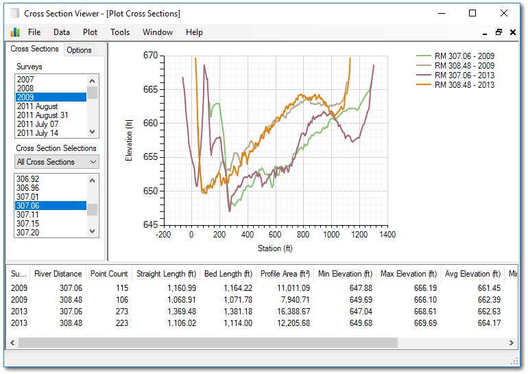
The Cross Section Viewer is an interactive software application for managing and visualizing river transect data. The software uses a simple data model that allows most types of transect data to be stored and viewed. A series of interactive tools include areal, profile and longitudinal plots as well as several geomorphic calculations that would typically take a user a considerable amount of time to produce.
Features
- Store virtually unlimited number of surveys, cross sections and points in a simple, structured database.
- View graphical plots of each cross section, along with reference stations and stages.
- Calculate and report many common river measurements, including:
- Transect areas.
- Incremental and cumulative depth distributions.
- Longitudinal volumes with planimetric areas and volumes - both incremental and cumulative.
- Bed elevation change - both total volume and average vertical change.
- Import survey data from CSV text files or HEC-compatible formats.
- Export survey as well plot data into CSV and HEC-compatible text file formats.
- View cross sections on an interactive map.
Citation
 If you use the Cross Section Viewer, please cite the following publication:
Shelley, John, and Bailey, Philip. 2018. The Cross Section Viewer: A Tool for Automating Geomorphic Analysis Using Cross Section Data. ERDC/TN RSM- 18-3. Vicksburg, MS: U.S. Army Engineer Research and Development Center. http://dx.doi.org/10.21079/11681/26284