The two most fundamental types of data stored in the Cross Section Viewer database are surveys and cross sections. A cross section is a single transect of surveyed points across a river. The word cross section or transect are used interchangeably within the software. Essentially a cross section is a single line across a river, typically perpendicular to flow. Within the software, cross sections are considered permanent, monumented transects that are surveyed repeatedly. Each cross section is identified by a database ID and a river mile. The database ID can be user defined or assigned by the software. The river mile is always user defined and represents a positive distance upstream from a user defined position (typically but not necessarily river mile zero, where the river terminates at the confluence with another water body).
A survey is a collection of cross sections that were collected as a single initiative. This might represent one field season’s worth of data, or smaller campaigns perhaps strategically related to some kind of flow. The most common use of surveys is to think of them as a single visit to each monumented cross section. Repeat surveys would then represent repeat visits to each cross section. In practice, surveys don’t always include every cross section.
Most analytical tools within the software are based on either a single survey or comparing two surveys together, so it’s important for users to develop a consistent strategy for organizing their survey data.
Surveys
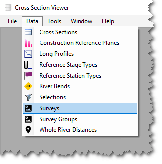
To view a list of surveys in the current database, select Data then Surveys. A list of surveys is displayed showing the river mile of the most downstream and upstream cross section surveyed as well as the total number of cross sections included in the survey.
To add survey, select Edit > Add and enter Name and Remark fields. Each survey must possess a unique name within the current database. Names can be anywhere between 1 and 255 characters long.
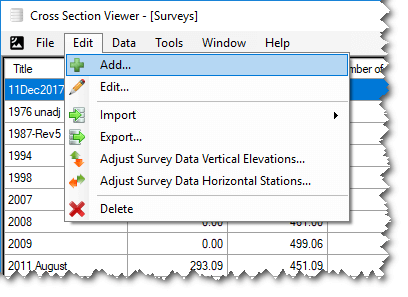
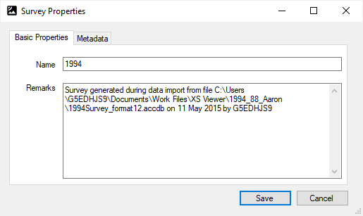
To edit survey properties, select (double-click, or right click and Edit) on the survey of interest. Edit the desired fields and then click Save. In addition to basic notes about the survey, you can store key-value pairs of metadata. Once you have added an item, you can double click the row in the metadata table to edit the metadata information on a pop-up form that is more convenient for entering longer text.
- Importing data into a survey is covered in the Import section.
- To export a list of surveys or delete survey data, see the Edt Menu Items help page.
- For more information on Adjusting Survey Data Vertical Elevation, see its help page.
Cross Sections
It is important to understand the distinction between a cross section definition and a cross section survey. These two concepts crop up throughout the software and, for the sake of saving space in the software user interface, are not always labeled consistently.
A cross section definition represents a fixed location along a river, analgous to a monumented transect location. This location does not change over time. It is identified by a database ID and a river mile. Sometimes these definitions are monumented with concrete structures, signs or other markers. Often each definition possesses a pair of start and end coordinates used for navigation.
A cross section survey represents a single visit to a cross section definition and the collection of a set of survey points along the defined cross section.
Each survey can only include each cross section definition once.
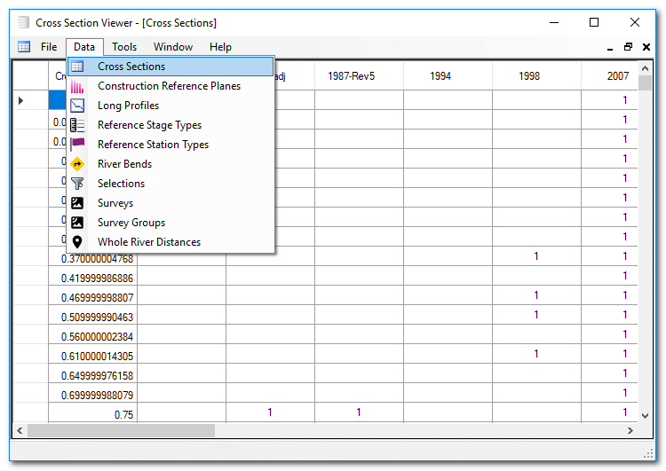
To view the set of defined cross sections within the current database, select Data then Cross Sections. The table that appears contains one row for each defined cross section and a column for each survey in the database. A 1 is displayed where the particular cross section definition was captured during the survey.
You cannot add, edit or delete cross section definitions directly. Rather, cross section definitions are created while importing survey data.
Units
When users create a new database they must define the units that pertain to the data they intend to store in the database. These units are then assumed whenever the user imports data into the database. The values provided are simply copied into the Cross Section Viewer data directly, with no unit version.
The only time that the Cross Section Viewer converts values between units is when calculating areas and volumes. The software uses the popular UnitsNet library for this purpose.
It is possible to discover what units are used for a particular database simply by opening one of the plot tools. The units are also displayed in the database information screen.
Creating a Cross Section Viewer database by importing a GCD project uses the units defined in the source GCD project. Similarly, converting a legacy Microsoft Access database uses the units defined in the source database.
Linear Units
River distances (down the channel), stations (across the channel) and elevations can be stored in any of the following units:
- Centimeter
- Decimeter
- Foot
- Inch
- Kilometer
- Meter
- Mile
- Millimeter
- US Survey Foot
- Yard
Area and Volume Units
Area and volume units are derived from the elevation units specified for each Cross Section Viewer database. Areas and volumes use the square and cubic equivalent of each unit. For example elevations stored in meters will have areas reported in meters squared and volumes in meters cubed. The one exception is that elevations stored in US survey feet have areas and volumes reported in standard square feet and cubic feet.
Note that the latest version of UnitsNet includes acre feet but that we have not upgraded to this version in the Cross Section Viewer software. We have an open issue to do so. Until then acre feet is not available in all tools.
Vertical Datums
Elevations are stored as 8-byte IEEE floating point numbers and refer to in one of two vertical datums:
The Cross Section Viewer does not perform any unit or datum conversion on elevation values. The values imported by the user are stored and then used directly in all displays and calculations. It is the user’s responsibility to ensure that all imported data use a consistent vertical datum.